Glossary
Acoustics
The science of sound, including the generation, transmission, and effects of sound waves, both audible and inaudible.
An entity holding a Certificate of Public Convenience and Necessity issued by the Department of Transportation (DOT) to conduct scheduled air services over specified routes and a limited amount of non-scheduled operations
Air Pollutant
Any substance in air that could, in high enough concentration, harm man, other animals, vegetation, or material. Pollutants may include almost any natural or artificial composition of airborne matter capable of being airborne. They may be in gases, particulates, or in combinations thereof. Generally, they fall into two main groups: (1) those emitted directly from identifiable sources and (2) those produced in the air by interaction between two or more primary pollutants, or by reaction with normal atmospheric constituents, with or without photo- activation.
Airman's Information Manual (AIM)
A publication containing basic flight information and air traffic control (ATC) procedures, designed primarily as a pilot's information and instructional manual for use in the National Airspace System.
Airport Operations
Landings (arrivals) and takeoffs (departures) from an airport.
Air Route Traffic Control Center (ARTCC or Center)
A Federal Aviation Administration (FAA) facility established to provide air traffic control service to aircraft operating on an Instrument Flight Rules (IFR) flight plan within controlled airspace and principally during the en- route phase of flight. When equipment capabilities and controller workload permit, certain advisory/assistance services may be provided to Visual Flight Rules (VFR).
Air Taxi
An air carrier certificated in accordance with Federal Aviation Regulations (FAR) Part 135 and authorized to provide, on demand, public transportation of persons and property by aircraft. Generally operates small aircraft “for hire” for specific trips.
Air Traffic Control (ATC)
A service operated to promote the safe, orderly, and expeditious flow of air traffic.
Aircraft Surveillance Systems
Systems set up to enable the Air Traffic Control (ATC) system to know the location of an aircraft and where it is heading. Aircraft positions are displayed for controllers as they actively monitor the traffic to ensure that aircraft do not violate separation criteria.
Airport Traffic Control Tower (ATCT)
The airport traffic control facility located on an airport that is responsible for traffic separation within the immediate vicinity of the airport and on the surface of the airport.
Airspace
Navigable area used by aircraft for purposes of flight.
Airway
An area of Class E airspace established in the form of a corridor, the centerline of which is defined by radio navigational aids. The network of airways serving aircraft operations up to but not including 18,000 feet Mean Sea Level (MSL) are referred to as “Victor” airways. The network of airways serving aircraft operations at or above 18,000 feet MSL are referred to as “Jet” airways.
Altitude
Height above a reference point, usually expressed in feet. Reference points are typically sea level, the ground, or airfield elevation in which case MSL, AGL or AFE further describes the altitude, respectively.
Ambient Noise Level
The level of noise that is all-encompassing within a given environment for which a single source cannot be determined. It is usually a composite of sounds from many and varied sources near to and far from the receiver.
Area Navigation (RNAV)
A method of air navigation that permits aircraft to operate on any desired course within a network of station-referenced navigation aids (NAVAIDs), rather than navigating directly to and from the NAVAIDs.
Arithmetic Averaged Sound Pressure Level
The arithmetic sum of a series of sound pressure levels divided by the number of levels included in the sum.
Arrival Stream
A sequence of aircraft that are following similar arrival procedures. This can conserve flight distance, reduce congestion, and allow instrument flight plans into airports with limited NAVAIDs.
Attainment Area
An area in which the Federal or state standards for ambient air quality are being achieved.
A-Weighted Sound Level
A quantity, in decibels, read from a standard sound-level meter with A-weighting circuitry. The A-weighting scale discriminates against the lower frequencies below 1000 hertz according to a relationship approximating the auditory sensitivity of the human ear. The A-weighted sound level is approximately related to the relative “noisiness” or “annoyance” of many common sounds.
Aviation System Performance Metrics
A broad collection of systems for reporting on the performance of approximately 29 airlines serving the 77 ASPM airports
Based Aircraft
Active aircraft that are stationed at an airport on a permanent basis.
Block
Census blocks are small areas bounded on all sides by visible features such as streets, roads, streams, and railroad tracks, and by invisible boundaries such as city, town, township, and county limits; property lines; and short, imaginary extensions of streets and roads. Blocks are numbered uniquely within each census tract or block numbering area (BNA). A three-digit number identifies a block, sometimes with a single alphabetical suffix. The U.S. Bureau of Census designates census blocks.
Categorical Exclusion (CATEX)
"Categorical exclusion" means a category of actions which do not individually or cumulatively have a significant effect on the human environment and which have been found to have no such effect in procedures adopted by a Federal agency in implementation of these regulations (Sec. 1507.3) and for which, therefore, neither an environmental assessment nor an environmental impact statement is required. An agency may decide in its procedures or otherwise, to prepare environmental assessments for the reasons stated in Sec. 1508.9 even though it is not required to do so. Any procedures under this section shall provide for extraordinary circumstances in which a normally excluded action may have a significant environmental effect.
Centroid
A point representing the geographic center of a US Bureau of Census’ census block.
Climb
The act or instance of increasing altitude.
Community Noise Equivalent Level
The average A-weighted sound level as measured in decibels during a 24- hour period. A 10 decibel weighting is applied to noise events occurring at night, and a 4.8 decibel weighting is applied to those occurring during the evening hours.
Conformity
A determination that a project conforms with a State Implementation Plan (SIP) whose purpose is to eliminate or reduce the severity and number of violations of the National Ambient Air Quality Standards; and does not impede the scheduled attainment of such standards.
Constructive Use
When the proximity impacts (e.g., noise) of a proposed project adjacent to, or near, a Section 4(f) property result in substantial impairment of the property.
Controlled Airspace
Airspace of defined dimensions within which air traffic control service is provided to IFR flights and to VFR flights in accordance with the airspace classification.
Corner-Post Configuration
Corner-post Configuration refers to an arrangement of air traffic pathways in a terminal area that brings incoming flights over fixes at four corners of the traffic area, while outbound flights depart between the fixes, thus minimizing conflicts between arriving and departing traffic.
Criteria Pollutants
The 1970 amendments to the Clean Air Act required EPA to set National Ambient Air Quality Standards for certain pollutants known to be hazardous to human health. EPA has identified and set standards to protect human health and welfare for six pollutants: ozone, carbon monoxide, total suspended particulates, sulfur dioxide, lead, and nitrogen oxide. The term, “criteria pollutants” derives from the requirement that EPA must describe the characteristics and potential health and welfare effects of these pollutants. It is on the basis of these criteria that standards are set or revised.
Day-Night Average Sound Level (DNL)
A measure of the annual average noise environment over a 24-hour day. It is the 24-hour, logarithmic- (or energy-) average, A-weighted sound pressure level with a 10-decibel penalty applied to the nighttime event levels that occur between 10 p.m. and 7 a.m.
De minimis Levels
De minimis is defined as lacking significance or importance, or so minor as to be disregarded. De minimis levels are minimum air pollutant levels and vary according to the type of pollutant and severity of the non-attainment area. Unless state minimums are lower than Federal, these levels are consistent for all conformity determinations. The calculation of total project emissions is made and compared to these de minimis cutoffs. If the emissions for a pollutant are above de minimis, the project requires a conformity determination. All emissions from the project must be analyzed and found to conform, not only those above the de minimis levels.
Decibel (dB)
Commonly used to define the level produced by a sound source. The decibel scale is logarithmic (e.g., when the scale goes up by ten, the perceived level is twice as loud).
Departure
The act of an aircraft taking off from an airport.
Departure Procedure (DP)
A preplanned IFR ATC departure procedure printed for pilot use in graphic and/or textual form.
Departure Procedures (DP) provide transition from the terminal to the appropriate en route structure. SIDs are a type of DP.
Descent
The process of decreasing altitude.
Design and Implementation Team (D&I team)
Air traffic controllers and airspace procedures specialists from the SCT TRACON facility and ZLA ARTCC, with additional participation by OAPM Program Office personnel.
Distance Measuring Equipment (DME)
Equipment installed on an aircraft that provides the distance of the aircraft in relation to a navigation aid as well as ground speed. Distance Measuring Equipment (DME) transmitters are often co-located with a Very High Frequency Omni-directional Radio Range Station (VOR), known in this case as a VOR-DME.
Downwind Leg
A flight path parallel to the landing runway in the direction opposite to the landing. The downwind leg normally extends between the crosswind leg and the base leg.
Emissions
Pollution discharged into the atmosphere from stationary sources such as smokestacks, surface areas of commercial or industrial facilities, residential chimneys, and from mobile sources such as motor vehicles, locomotives, or aircraft exhausts.
En Route Airspace
A general term to describe the airspace controlled by an ARTCC.
Energy-Averaged Sound Pressure Level
The logarithmic sum of the sound power of a series of sound pressure levels divided by the number of levels included in the sum.
Enplanement
The total number of revenue passengers boarding aircraft, including originating, stopover, and transfer passengers, in scheduled and non-scheduled services.
Environmental Assessment (EA)
A concise document that assesses the environmental impacts of a proposed Federal Action. It discusses the need for, and environmental impacts of, the proposed action and alternatives. An environmental assessment should provide sufficient evidence and analysis for a Federal determination whether to prepare an Environmental Impact Statement (EIS) or a Finding of No Significant Impact (FONSI).
Environmental Impact Statement (EIS)
An EIS is a document that provides a discussion of the significant environmental impacts which would occur as a result of a proposed project, and informs decision-makers and the public of the reasonable alternatives which would avoid or minimize adverse impacts.
Environmental Noise
Unwanted sound from various outdoor sources that produce noise (e.g., aircraft, cars, trucks, buses, railways, industrial plants, construction activities).
Equipage
Communication, navigation and surveillance equipment installed on an aircraft.
Equivalent Sound Level (Leq)
The level of a constant sound, which, in the given situation and time period, has the same average sound energy, as does a time-varying sound. Specifically, equivalent sound level is the energy-averaged sound pressure level of the individual A-weighted sound pressure levels occurring during the time interval.
Federal Aviation Administration (FAA)
The FAA is the agency of the United States Department of Transportation with primary responsibility for civil aviation. Among its major functions are the regulation of civil aviation to promote safety, fulfill the requirements of national defense and development, and operate a common system of air traffic control and navigation for both civil and military aircraft.
Federal Infrastructure Projects Dashboard
Part of an inter-agency initiative, spearheaded by the Office of Management and Budget, to institutionalize best practices to reduce the amount of time required to make permitting and review decisions and improve environmental and community outcomes.
Finding of No Significant Impact (FONSI)
If, following the preparation of an environmental assessment, the Federal agency determines a proposed project will not result in any significant environmental impact, a finding of no significant impact (FONSI) may be issued by the Federal Agency. A FONSI is a document briefly explaining the reasons why an action will not have a significant effect on the human environment and for which an EIS, therefore, is not necessary.
Fix
A geographical position determined by reference to one or more radio NAVAIDS, celestial plotting, or by some other means such as satellite navigation.
Flight Data Information
Specific information used by ATC for an individual flight, including information such as aircraft identification, destination, type, route, and altitude.
Flight Track
The path an aircraft describes over the ground.
Flow
Describes the direction in which aircraft take-off and land at a particular airport. Aircraft generally take-off and land into the wind. However, other factors (e.g., nearby airports, construction) can also affect flow.
Flyways
Migration routes for avian species.
Frequency (acoustic)
The number of oscillations per second completed by a vibrating object.
General Aviation (GA)
All civil aviation except scheduled passenger, air taxi and cargo airlines.
Global Positioning System (GPS)
A satellite-based radio positioning and navigation system operated by the U.S. Department of Defense. The system provides highly accurate position and velocity information, and precise time, on a continuous global basis to an unlimited number of properly equipped users.
Hand-Off
An action taken to transfer the radar identification of an aircraft from one controller to another.
Heading A compass bearing indicating the direction of travel.
Hertz (Hz)
The unit used to designate frequency; specifically, the number of cycles per second.
Household
A household includes all the persons who occupy a housing unit. The occupants may be a single family, one person living alone, two or more families living together, or any other group of related or unrelated persons who share living arrangements.
Housing Unit
A housing unit is a house, apartment, a mobile home or trailer, a group of rooms or a single room occupied as separate living quarters or, if vacant, intended for occupancy as separate living quarters.
Hydrocarbons (HC)
Chemical compounds that consist entirely of carbon and hydrogen.
Instrument Approach Procedure
A series of predetermined maneuvers for the orderly transfer of an aircraft under instrument flight conditions from the beginning of the initial approach to a land or to a point from which a landing may be made visually. It is prescribed and approved for a specific airport by a competent authority.
Instrument Departure Procedure
A preplanned IFR departure procedure published for pilot use, in graphic or textual format, that provides obstruction clearance from the terminal area to the appropriate en route structure. There are two types of DP, Obstacle Departure Procedure (ODP), printed either textually or graphically, and, Standard Instrument Departure (SID), which is always printed graphically.
Instrument Flight Rules (IFR)
Rules governing the procedures for conducting instrument flight in aircraft. Also a term used by pilots and controllers to indicate type of flight plan.
Instrument Meteorological Conditions (IMC)
Weather conditions expressed in terms of visibility, distance from clouds, and cloud ceilings during which all aircraft are required to operate using IFR.
Integrated Noise Model (INM)
A computer program developed, updated and maintained by the Federal Aviation Administration to evaluate aircraft noise impacts in the vicinity of airports.
In-Trail Spacing
The distance between two aircraft on an identical route; one aircraft is following another.
Invasive Species
Invasive species are organisms (usually transported by humans) that successfully establish themselves in, and then overcome, otherwise intact, pre-existing native ecosystems.
Knots
Speed measured in nautical miles per hour.
Level-off
The process by which an aircraft that is climbing or descending transitions to a constant altitude. This can be done once the aircraft reaches its cruise altitude in the en route environment, or as a series of steps taken as the aircraft transition to/from the en route environment to guarantee adequate separation from other aircraft.
Loudness
The attribute of an auditory sensation in terms of which sounds may be ordered on a scale extending from soft to loud. Loudness depends primarily upon the sound pressure of the source, but it also depends upon the frequency and waveform of the source.
Low-Income
A person whose median household income is at or below the Department of Health and Human Services poverty guidelines.
Mean Sea Level (MSL)
The height of the surface of the sea for all stages of the tide, used as a reference for elevations or altitude of aircraft flight. Also called sea level datum.
Metroplex
A geographic area containing several airports serving major metropolitan areas and a diversity of aviation stakeholders.
National Airspace System (NAS)
The common network of U.S. airspace; air navigation facilities, equipment, services, airports, or landing areas; aeronautical charts, information, and services; rules, regulations, and procedures; technical information, manpower, and materials, all of which are used in aerial navigation.
National Ambient Air Quality Standards (NAAQS)
Standards for criteria pollutants established by United States Environmental Protection Agency that apply to outdoor air.
National Environmental Policy Act of 1969 (NEPA)
The basic national charter for protection of the environment, NEPA ensures that high quality, accurate scientific analysis and environmental information is available to public officials and citizens before decisions are made and before actions are taken.
Nautical Mile (NM)
A measure of distance equal to 1 minute of arc on the earth’s surface (approximately 6,076 ft. or approximately 1.15 statute miles).
Navigation Aids (NAVAIDs)
Any visual or electronic device airborne or on the surface that provides point to point guidance information or position data to aircraft in-flight.
Next Generation Air Transportation Systems (NextGen)
A program shifting aircraft procedures from fixed, ground-based radio navigation transmitting facilities and radar to satellite, or Global Positioning System (GPS), navigation and onboard surveillance.
Noise
Any sound that is undesirable because it interferes with speech and hearing, or is intense enough to damage hearing, or is otherwise annoying.
Noise Abatement Procedure
A measure taken to reduce the off-airport impacts of aircraft noise through changes in airport layout or aircraft operations. Noise abatement procedures are generally developed by airport operators in cooperation with the FAA, aircraft operators, pilots, and other aviation interests, to address noise concerns raised by residents and local community officials.
Noise Exposure
The cumulative acoustic stimulation reaching the ear of a person over a specified period of time (e.g., a work shift, a day, a working life, or a lifetime).
Noise Integrated Routing System (NIRS)
A computer program developed, updated, and maintained by the FAA to evaluate aircraft noise impact for air traffic actions involving multiple airports over broad geographic areas.
Non-Attainment Area
Areas with levels that exceed one or more of the NAAQS for the criteria pollutants designated in the Clean Air Act.
SoCal OAPM Airports
These are the airports that are the subject of the Proposed Action.
Operation Landing or take-off of an aircraft.
Operational Evolution Partnership (OEP)
Operational Evolution Partnership airports are commercial U.S. airports with significant activity. These airports serve major metropolitan areas and also serve as hubs for airline operations. More than 70 percent of passengers move through these airports. Currently, there are 35 OEP airports.
Operation
Landing or take-off of an aircraft.
Optimization of Airspace and Procedures in the Metroplex (OAPM)
Following the recommendations of the Aviation community the FAA created an initiative called the Optimization of Airspace and Procedures in the Metroplex
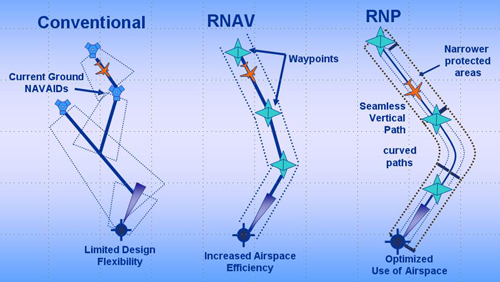
Performance Based Navigation
Performance-Based Navigation (PBN) is comprised of Area Navigation (RNAV) and Required Navigation Performance (RNP) and describes an aircraft’s capability to navigate using performance standards.
Area Navigation (RNAV)
RNAV enables aircraft to fly on any desired flight path within the coverage of ground- or space-based navigation aids, or within the limits of the capability of aircraft self-contained systems, or a combination of both capabilities.
Required Navigation Performance (RNP)
RNP is RNAV with the addition of an onboard performance monitoring and alerting capability. A defining characteristic of RNP operations is the ability of the aircraft navigation system to monitor the navigation performance it achieves and inform the crew if the requirement is not met during an operation. This onboard monitoring and alerting capability enhances the pilot’s situation awareness and can enable reduced obstacle clearance.Certain RNP operations require advanced features of the onboard navigation function and approved training and crew procedures. These operations must receive approvals that are characterized as Authorization Required (AR), similar to approvals required for operations to conduct Instrument Landing System Category II and III approaches.
Piston Aircraft
Propeller-driven aircraft powered by an internal combustion engine.
Power Settings
Amount of engine power used by the pilot.
Procedural Deconfliction
Defined altitude or lateral restrictions as part of a procedure to keep aircraft from conflicting with other aircraft on different procedures.
Proposed Action
The action proposed by a Federal Agency.
Purpose and Need
Identifies the "problem" being addressed by the project (need) and how that problem would be addressed by the project.
Q-route
Q-routes are available for use by RNAV equipped aircraft between 18,000 feet MSL and FL 450 inclusive. Q-routes are depicted on En Route High Altitude Charts.
Quadrant
A quarter part of a circle, centered on a NAVAID oriented clockwise from magnetic north.
Radar (primary)
A device which, by measuring the time interval between transmission and reception of radio pulses, and correlating the angular orientation of the radiated antenna beam, or beams in azimuth and/or elevation, provides information on range, azimuth, and /or elevation of objects in the path of the transmitted pulses. Also known as “Primary Radar”.
Radar (secondary)
A radar system in which the object to be detected is fitted with cooperative equipment in the form of a radio receiver/transmitter (transponder). Radar pulses transmitted from the searching transmitter/receiver (interrogator) site are received in the cooperative equipment and used to trigger a distinctive transmission from the transponder. This reply transmission, rather than a reflected signal, is then received back at the interrogator site for processing and display at an ATC facility. Also known as a “Radar Beacon”.
Radial
A magnetic bearing extending from a VOR/VORTAC/TACAN navigation facility.
Record of Decision (ROD)
Documents the FAA's decision on the Proposed Action, how the decisions were made, alternatives considered including the Proposed Action, and the preferred alternative; and discusses what mitigation measures are being imposed to lessen significant environmental impacts.
RNP/RNAV
Reduced Vertical Separation Minima
A reduction in the vertical separation requirement for flights above flight level 290, from 2,000 ft. minimum to 1,000 ft minimum.
Required Navigation Performance (RNP)
A type of performance-based navigation (PBN) that allows an aircraft to fly a specific path between two 3-dimensionally defined points in space. RNP differs from RNAV systems in that there is a requirement for on-board performance monitoring and alerting specification. See Performance-Based Navigation (PBN).
Satellite Navigation
See Global Positioning System (GPS).
Section 4(f)
A property that may be protected under special provisions of the U.S. Department of Transportation Act, 49 USC 303(c).
Sector
A defined volume of airspace, including both lateral and vertical limits, in which an air traffic controller is responsible for the safe movement of air traffic. A TRACON's or ARTCC's airspace is comprised of multiple sectors.
Separation
Required FAA minimum spacing between aircraft.
Sequencing
A process used to merge air traffic into an orderly flow.
Sound Exposure Level (SEL)
A time-integrated metric (i.e., continuously summed over a time period) that quantifies the total energy in the A-weighted sound level measured during a transient noise event. The time period for this measurement is generally taken to be that between the moments when the A-weighted sound level is 10 dB below the maximum. Sound Pressure Level A measure, in decibels, of the magnitude of the sound. Specifically, the sound pressure level of a sound that is 10 times the logarithm to the base 10 of the ratio of the squared pressure of this sound to the squared reference pressure. The reference pressure is usually taken to be 20 micropascals. See also Energy-Averaged Sound Pressure Level.
Source (acoustic)
The object that generates the sound.
Special Aircraft and Aircrew Authorization Required
RNP instrument approach procedures with Authorization Required or RNP AR approach procedures build upon the performance based NAS concept.
Standard Instrument Approach Procedure (SIAP)
A series of predetermined maneuvers for the orderly transfer of an aircraft under instrument flight conditions from the beginning of the initial approach to a land or to a point from which a landing may be made visually. It is prescribed and approved for a specific airport by a competent authority.
Standard Instrument Departure Procedure (SID)
A preplanned IFR departure procedure published for pilot use, in graphic or textual format, that provides obstruction clearance from the terminal area to the appropriate en route structure.
Standard Terminal Arrival (STAR)
A preplanned IFR air traffic control arrival procedure published for pilot use in graphic and/or textual form. STAR's provide transition from the en route structure to an outer fix or an instrument approach fix/arrival waypoint in the terminal area.
Statute Mile (SM)
A measure of distance equal to 5,280 feet.
Sulfur Dioxide (SO2)
Sulfur dioxide typically results from combustion processes, refining of petroleum, and other industrial processes.
Tactical Separation
The separation of aircraft by air traffic control instruction versus procedural deconfliction.
Terminal Area
A general term used to describe airspace in which approach control service or airport traffic control service is provided.
Terminal Radar Approach Control (TRACON)
An FAA ATC facility that uses radar and two-way radio communication to provide separation of air traffic within a specified geographic area in the vicinity of one or more large airports.
Threshold of Significance
A threshold of significance is a quantitative or qualitative standard, or set of criteria, pursuant to which the significance of a given environmental effect may be determined. These standards or criteria are established by the lead government agency performing a NEPA review, in this case the FAA.
T-Route
T−routes are available for use by RNAV equipped aircraft from 1,200 feet above the surface (or in some instances higher) up to but not including 18,000 ft. MSL.